NepTrack
NepTrack is a GPS tracking and vehicle intelligence platform built specifically for Nepal. It is designed to help businesses and organizations manage their fleets of vehicles while ensuring safety and compliance with local laws. The system is engineered within Nepal to handle the country's unique terrain, including mountains and hills, where GPS signals might sometimes be weak. All data collected by the platform is stored locally in Nepal, which protects national data sovereignty and meets government regulations.
Benefits
NepTrack offers several key advantages for fleet managers and businesses operating in Nepal.
First, it ensures full compliance with the Department of Transport Management and the Nepal Telecommunications Authority. This means businesses can operate without legal issues while maintaining accurate records.
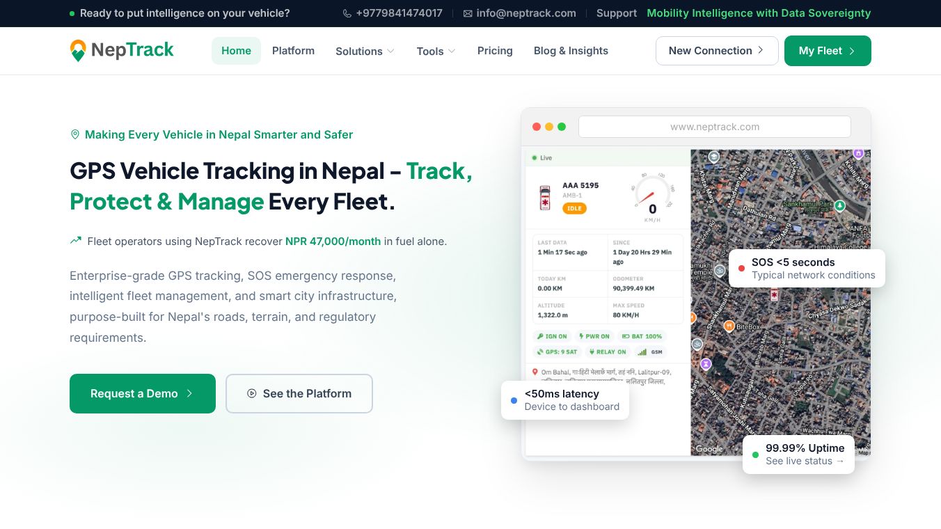
The platform provides real-time tracking with extremely fast response times. It achieves a latency of less than 50 milliseconds between the device and the dashboard. This speed allows for instant alerts and immediate action.
It supports the local Nepali calendar known as Bikram Sambat, making it easier for local users to interpret dates and schedules.
When GPS signals are lost in hilly or mountainous areas, the system automatically switches to Location Based Services and Wi-Fi triangulation. This ensures continuous tracking even in remote locations.
The system supports remote control features. Managers can remotely cut fuel or immobilize vehicles to prevent theft or unauthorized use. Every action is logged in an immutable audit trail for security.
It offers advanced emergency response capabilities. In case of an accident, the system can detect the collision and dispatch help within five seconds. Citizens can track the responder in real time.
Use Cases
NepTrack is suitable for a wide range of industries and vehicle types across all seven provinces of Nepal.
Public transport companies can use it to track buses and microbuses. The system provides live arrival times for passengers and helps operators monitor route deviations. It also generates reports on fuel usage and on-time performance.
Corporate businesses can manage their private cars, delivery vans, and trucks from a single dashboard. The platform retains trip history for five years, allowing companies to review past routes and performance.
Municipalities can optimize waste management operations. The system plans efficient routes for garbage trucks and notifies residents when a truck is approaching their area. It also tracks missed or delayed pickups.
Electric vehicle charging stations can be managed using the platform. It supports standard charging protocols and provides real-time data on energy usage and billing. Fault alerts notify operators before users are affected.
Emergency services can use the SOS features to coordinate ambulance or police responses. The system identifies the nearest available vehicle and sends multi-channel alerts via SMS, WhatsApp, or app notifications.
Developers and website owners can integrate the platform using open APIs. They can embed live maps on their websites or build custom applications using official SDKs for Flutter and Node.js.
Pricing
Pricing details for NepTrack are not available in the provided information. The platform likely offers custom pricing based on the number of vehicles and specific features required.
Vibes
Public reception and specific customer testimonials are not available in the provided information. The platform is described as Nepal's only GPS tracking and vehicle intelligence platform, indicating a strong market position.
Additional Information
NepTrack is funded and developed entirely within Nepal. It is built to scale from a single vehicle to a fleet of over three million vehicles. The architecture supports sub-5 millisecond geofence queries to maintain performance as the system grows.
The platform maintains a 99.9 percent uptime service level agreement. It operates across all seven provinces of Nepal and supports a wide variety of vehicle types including two-wheelers, school buses, and ambulances.
The system provides open API access which is unique among GPS platforms in the region. It includes REST APIs for data retrieval and a Data Stream API for real-time updates. Official open-source SDKs are available for popular programming languages under the Apache 2.0 license.
All data is hosted locally in Nepal to ensure data sovereignty and compliance with national regulations. The platform includes features like tamper detection and five-year data retention to meet government requirements.
This content is either user submitted or generated using AI technology (including, but not limited to, Google Gemini API, Llama, Grok, and Mistral), based on automated research and analysis of public data sources from search engines like DuckDuckGo, Google Search, and SearXNG, and directly from the tool's own website and with minimal to no human editing/review. THEJO AI is not affiliated with or endorsed by the AI tools or services mentioned. This is provided for informational and reference purposes only, is not an endorsement or official advice, and may contain inaccuracies or biases. Please verify details with original sources.


Comments
Please log in to post a comment.